Islanders, here we go again.
Last November’s atmospheric river smashed rainfall records across the Island and mainland. Extensive flooding damaged highways, homes, businesses and farms. Insurers say it was Canada’s costliest natural disaster.
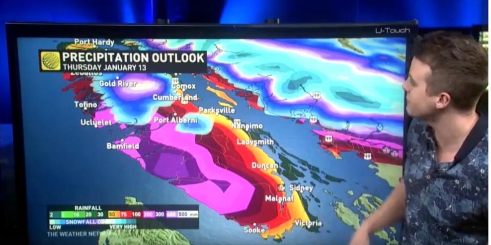
Now, after a couple of cold but sunny days, the rains are about to arrive. And not just average rainfall. These could be heavy. Since the icepack hasn’t yet cleared, this could be a problem in some areas on the Island.
Freezing levels are rising to 2,000 metres, and rainfall across the North Island region could reach 100 mm through Thursday. The new rain forecast, coupled with the recent heavy snowpack, has many island communities bracing for floods.
Meteorologists are tracking several moisture-heavy weather systems. The first is set to arrive Monday evening.
That’s why on Sunday afternoon, the BC River Forecast Centre issued a High Streamflow Advisory for the South Coast and all of Vancouver Island. No major flooding is expected, but in some low-lying areas, minor flooding is possible.
However, Forecast Centre hydrologist Johnathan Boyd called the combination of heavy rain and deep snow already on the ground a “concerning situation.”
Boyd told Global News that current modelling indicates the storm could be the worst and wettest on central Vancouver Island and the Sunshine Coast.
The combination of heavy rain and snowmelt could lead to rapid increases in stream and river flows, as well as erosion of banks and adjacent properties.
The one silver lining is that temperatures will be in the 9 to 10 C range during this storm cycle. That means precipitation will likely fall as snow and not rain at higher elevations, which could be a saviour for downstream Island communities.
Snowpack depth throughout BC is higher than average so far this year. Numerous storms in December and early January have helped build up the mountain snowpack, particularly on the South Coast, Vancouver Island and the Southern Interior.
La Nina conditions, which typically bring cool and wet weather to BC, are expected to continue through the winter. This bodes well for lakes, rivers and streams next summer.
But in the meantime, get ready because it’s going to be a wet one.

